 We left Bonnyville on Thursday August 5th, quickly re-geared and left for the Yoho Valley (just on the other side of the Divide from Lake Louise) on the 6th. Travelling north from Field, we arrived at Takakkaw Falls and the trail head at 6 PM. Our plan was to hike the 8 km trail from Takakkaw Falls to the Twin Falls campground that evening, meet up with Martin's daughters Nicole and Aline and their partners Lee and Mike (respectively) who were coming behind us, then hike the relatively short but difficult hike from Twin Falls, over Whaleback Mountain, then up to the Little Yoho campground. The third day would be the climax: the world famous Iceline Trail that travels above the treeline along rocky moraines, past the toes of magnificent alpine glaciers, then decends back to the valley bottom at Takakkaw Falls. The entire trip would be 26 km. Jacqueline is standing beside a small gorge on the Yoho River during that first evening. It was a pleasant and, for the most part, gentle hike to Twin Falls. Not much for views, but a beautiful rain forest (a rare thing in the Rocky Mountains), tons of amazing waterfalls, and clean fresh air.
 This was our first view of Twin Falls on Friday evening. The thing about a rain forest is that it rains a lot. This was the third time that Jacqueline and Martin have hiked this trail, and the only time that there was no rain. We were thrilled to be able to see the falls from a distance. From the valley bottom to the top of the falls is about 300 meters (1000 feet). The hike to the top of the falls is the first part of the hike that we will have to do on the second day.
 By the time that we arrived at the Twin Falls campsite, set up camp and had dinner, and welcomed the rest of the party as they straggled in to camp, it was late and too dark for photos. Up and at 'em the next morning, we were off to the Whaleback, a long mountain that has the appearance of a humpback whale cresting the water (see the Newfoundland posting on our blog for examples). We quickly came upon the Twin Falls Chalet. It was built by the Canadian Pacific Railway in the early 1900's as a destination for tourists who wanted to experience the backcountry, either on foot or by horseback. This is now a national historic site - as evidenced by the very historic looking plaque that you see in the foreground. It is also still functioning as a backcountry lodge where you can sleep in relative comfort, rather than in a tent on the ground as we were doing. Martin thinks that lodges like this are for wussies, unless it's winter and you are backcountry skiing, in which case Martin thinks that people are too old to sleep outside in snow shelters.
 This is the top of the Twin Falls. We see here the main channel, leading to the larger chute of the Twin Falls. When the CPR set up the chalet, the second smaller chute would only flow intermittently depending on the amount of water coming in, so they blew open the top of the waterfall with dynamite (!) in order to make the two chutes run reliably. What would the environmentalists say today?
 This is the view looking down from the falls at the chalet where we had started earlier that morning.
 Of course, it rained. The first time that Martin and Jacqueline hiked this trail, they had six teen aged children with them, and it poured rain. This time the children were adults, and it rained much less, but there was still a moderate amount of whining. The views, however, were incredible. This is is the view looking across Yoho Valley at the Fairy Glacier.
 Nicole, Lee and Jacqueline ready to go after our lunch at the top of the falls.
 Aline and Mike, full of enthusiasm. Mike was in full mountain man costume.
 Nicole loved to amuse us with her Humpback of Notre Dame impression.
 Jaw -dropping views everywhere that you looked.
 This is the view from the summit of the Whaleback trail, looking across the Little Yoho Valley to the President Range and the Emerald Glacier. Behind the mountain in the photo is Emerald Lake and the Emerald Lake Lodge. Just below the treeline is an area of beautiful mountain meadows. Jacqueline was taken by this view, especially because it looked like a golf course! This would be our objective for the third day. The Iceline Trail runs just above the green area, along these glaciers.
 Another view of the Emerald Glacier as we descended from the Whaleback. This is when the rain really began to fall.
 A closer view of the mountain meadows across the valley.
When it rained there was a lot of it, and we were grateful for good gear. We were fortunate that throughout this trip, it only rained when we were walking, and generally in forested areas without any views. By the time we reached the Little Yoho campsite on the evening of the second day, the rain had paused and we were able to set up camp and get dinner going. By the time it started again, we were comfortably established under a large tarp. This is the view looking west from our camp.
 The next morning was remarkable - bright and sunny, and warm given the location. The Little Yoho campsite is at 6500 feet, and it can snow any time (one year in August we woke up t 10 cm. of snow.
 Aline is busy packing up as we prepare to leave for the Iceline Trail.
 What a great place to wake up in the morning! The air was crisp and clear, and the mountains looked as bright as jewels.
 This is looking back from the direction that we had come from, after the trail emerges from the forest. The pile of gravel that you see is the edge of the moraine pushed there by an advancing alpine glacier. They look like they were pushed up yesterday, and in fact are likely only a few hundred years old. Aline, our budding geologist, pointed out that the alpine glaciers in this area were advancing until about 300 years ago.
 We had views of peaks and glaciers in every direction. At one point we counted 8 glaciers that we could see in our immediate vicinity.
 Aline and Mike taking a break.
 This was our view from the treeline. The small valley below is the Little Yoho.
 The ridge in the background is the Whaleback, the mountain that we traversed the day before.
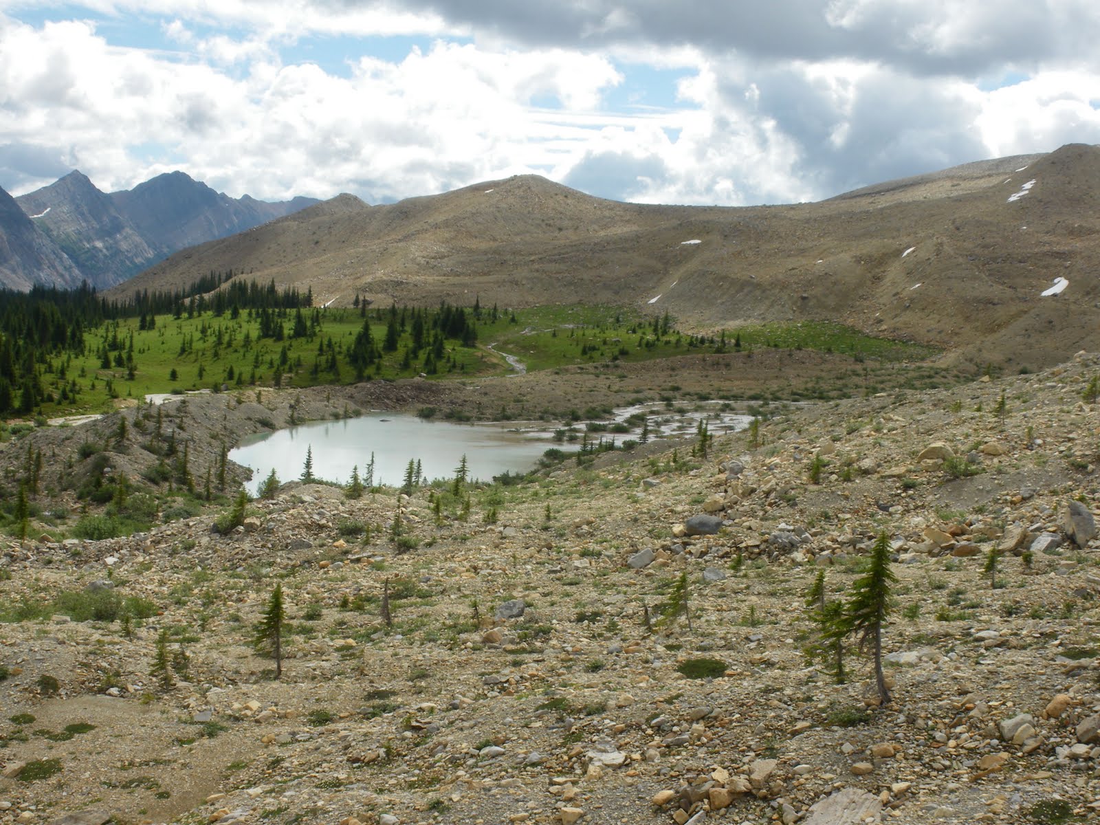 This is the view looking south along the Iceline Trail. The trail follows along the moraines, above the subalpine and alpine areas. There used to be a Skyline Trail that travelled through the alpine ares, but this was decommissioned because of the damage caused to the sensitive vegetation in the area. The Iceline has much less environmental impact, and is stunningly beautiful.
 This is the glacier that we saw from across the valley the day before, and here we were, walking immediately below it. The mountain behind the glacier is the Vice President. For those of you who have been to the Emerald Lake Lodge, these are the mountains that overlook the lake. We are looking at the north facing aspects, the south facing aspects can be seen from Emerald Lake.
 Sometimes the terrain seemed so foreign that it felt like we were walking on another planet.
 Glaciers everywhere, and a gorgeous day to enjoy them.
 Here we were, travelling through a moonscape.
 This is the view looking south towards the Yoho Valley. The peak in the photo is Mount Niles, with the Daly Glacier below and to the left. This drains in to Takakkaw Falls on the lower right. From below, the falls are incredibly high, but from this perspective you can see the terrain that leads in to them - even more spectacular!
 In the very bottom of this photo you can see the trail that we were following.
 We are descending back in to the valley at Takakkaw Falls.
 Success, and back to civilization. except for a minor knee injury that Nicole suffered when she fell during the descent on a slippery, steep trail through the rainforest, we were all in great shape at the end of the trip. Can't wait until next time!