Monday, March 14, 2011

Manele Bay Sweetheart Rock Point, Lanai Hawaii


We went to Manele Bay Resort to spend our last day at Hulope Bay on the beautiful beach swimming and riding the waves. We took a walk along the beach coastline towards the Sweetheart Rock.Tidal pools have formed in the lava rock around the bay and you can see some pretty interesting sea life.


Martin is standing over one here observing sea life in some tiny holes filled with sea water.


The waves kept rushing in filling up these pot holes.


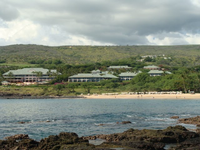
This is the view looking back on the Manele Resort and Hulopoe Bay. You can just make out the white umbrellas on the beach.


These are some condominiums just below the golf course.


Back to our observations of the sea pools. Above are a couple of sea urchins, a pink and a green one.


Look at the one above, those tentacles were moving across the rocks. some of the tentacles were two metres long and moving around on the rocks.


Another pretty little fish.


This cute little girl had all these sand crabs collected in a pool she had made. I asked her mother how she could play with them without getting bit and she said they cut off their pinchers, hence the pocket knife!


As we continued our walk around to the point of the bay we were able to get a great view of the Sweetheart Rock. It was so beautiful especially in the late afternoon sunlight.


Looks like a private beach. There were footprints in the sand but we couldn't figure out how anyone could get down there safely.


We have lots of pictures because it was so beautiful and it wasn't long before the sun would set. The day before we were out here we had the most incredible sunset ever, but we didn't have our camera with us! So we brought our camera this time in hopes to capture the sunset this time.


We could have watched the waves coming in and out of this shoreline all night if time permitted. It was so beautiful here, the rock is so richly red in colour and the sunset cast such a gorgeous light we couldn't stop taking pictures.


Sweetheart Rock Point is a very romantic spot!


We kept trying to get a good shot of the waves crashing against the rocks, it is so impressive! We took lots of videos too!


This picture is looking back to the resort from where we were at Sweetheart Rock.


Here is the start of the sunset and it is beautiful but it didn't have the colours like the one the night before. That night there were a few wispy clouds that turned these beautiful blues, purple and fuchsia colours that made it so spectacular! But this one will do too.


Notice the changes in the colour of the sky as the sun sets...


There she goes! Our last day here was wonderful, relaxing by the beach, exploring the tidal pools and enjoying this beautiful sunset out at Sweetheart Rock Point, we couldn't ask for anything better.


We walking back up to the resort from the beach on the trail lined with torches to light our way. It sure was hard to leave but we'll remember this beautiful place and would come back another time.


I missed this pretty gazebo in the garden of the lodge so I had to take a picture before we boarded our bus for the airport.


Island Air flew us out of Lanai to Honolulu to catch our flight home. We had a great time here and enjoyed everything this little island had to offer. As I'm doing this blog and reviewing all the pictures and the memories, I really want to go back there sooner than I thought!

Koloiki Ridge Hike, Lanai Hawaii


We were anxious to hike one of the trails on the island, but the night before our planned outing a huge (and apparently rare) thunderstorm dumped an impressive amount of rain. The employees at the hotel had advised us not to head out because of their concern that the storm could have left the trail impassable. We thought we'd try it and come back if it was too difficult. It wasn't a long hike, 5 miles round trip and degree of difficulty rated moderate but it we found only one spot that was technical, while the rest was a gentle walk. The scenery was well worth it!


Here is me in front of the Garden Pagoda as we head up towards the Koele golf course where the trail head starts.


The Koele golf course is beautiful! The next two pictures is the 17th hole which is their signature hole. The golfers tee off an elevated tee box which is above us so we had to watch out for them before we crossed the fairway.


We walked across the golf course where the trail began to narrow down to a single track trail winding though thick forest. It was slippery there but we took our time. This was the most difficult part of the hike, but really not too bad. We descended down a sloping hill with a thick stand of Waiawi (a type of Guava).


We travelled on a road that once served as a service road for the tunnels that carry drinking water from Maunelei Gulch to Lana'i City. The island has a large number of Axis deer that were introduced from Asia (more deer than people!). Apparently you can hear the deer's high pitched 'bark' which is their alarm sound. We didn't here anything but the birds, which are plentiful and varied


The above and below picture is the Sisal plant. The picture below is the top half of this plant as it was so tall we couldn't get into one picture. Really cool. We were following the Munroe Trail up the hill.


At this point we entered Kukui Gulch. The gets it's name from the many Kukui (Candle Nut) trees that grow here. The beginning of the gulch is marked by Yellow Ginger Plants and this part of the trail becomes part of the gulch wash which becomes quite muddy during their rainy season.


Here we are surround by the Ironwood trees.


Now the trail opens up and we're about to experience the incredible vistas of the rugged north side of Lana'i. To our left is Naio Gulch and our right is Maunelei Gulch. We had a clear day so we could see the island of Moloka'i and the island of Maui. Absolutely incredible!! We could not take enough pictures!


Above is Maunalei Gulch, the widest valley on the island. Ancient chants tell of the clouds bringing the misty rain of Kane to feed its streams. Bordered with a forest of Ahakea trees, this was the chosen place for the cultivation of Kalo or Taro, the Hawaiian staple food. Today, the gulch is a watershed preserve for the island, and access is restricted.


Above is the Naio Gulch, a name derived from the Naio Tree, prized for its scented wood. The wood is yellow in color with a scent closely resembling the rare 'iliahi' of Hawaiin Sandalwood.


More pictures of Maunalei Gulch. The view here is breath taking! This is Hawaiian scenery at its most magnificent.


Martin made me nervous as he stepped down below me to get this perspective. The ravine was so steep, a slip would be disastrous.


Maui is in the background. The West Maui Mountain range of Mount Pu'u Kukui protected the home of ancient Hawaiian Ali'i at Lele or what is today called Lahaina.


Beautiful shot of Maunalei Gulch with the sun shining down on the valley.


Very green and lush on the mountain.


Here is the island of Molokai. It's southern shorelines are dotted with more than 70 ancient Hawaiian fishponds, evidence of advanced aqua culture technology found nowhere else in the Pacific.


I found a rock that I could sit and feel more secure as I took in the view all around me. I was so stunningly beautiful! I was so thrilled to have experienced this hike as it gives you a wonderful perspective of what the island has to offer. It would be a shame to come to this island and not see this magnificent sight.


There was only two other couples we ran into on the trail, so we were able to enjoy the solitude along the trail and magnificent valleys of the Koele uplands. We were ready to leave when another couple arrived. They volunteered to take our picture and we took theirs. One of these pictures will be seen on of our walls at home!